IMMAGINI RELATIVE AI MIEI MESSAGGI
per il FORUM FILATELIA e FRANCOBOLLI pagina 91
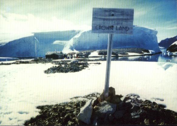
FORUM CONTINUA 91: qui proseguiamo con reperti filatelici per i TERRITORI ESTERNI del Regno Unito. Ma specificatamente alle loro basi in Antartide (filatelia polare), con anche molte cartoline di isole ESTREME! Quindi ben 3 tematiche che si intersecano!
Per vedere i link ai vari Territori esterni vai a:
-per i territori ESTERNI USA a pagina 69 (e a pagina 69aa per gli annulli militari APO e FPO)
-per i Territori ESTERNI di Francia, Norvegia e Spagna a pagina 69a
- per i Territori ESTERNI del Regno Unito a pagina 69b
Le pagine 69xx sono in continuo aggiornamento, quindi visitatele spesso, se vi interessa questa tematica di GEOGRAFIA POLITICA.
Basi antartiche:
British Antarctic Territory BAT, Definitive Current in Use
Bases & Postmarks :
|
1
|
Base
G Admiralty Bay |
|
2 |
Base
B Deception Island |
|
5
|
Base
D Hope Bay |
|
22
|
Base
F Argentine Islands |
|
25
|
Base
E Stonington Island |
|
40
|
Base
A Port Lockroy |
|
45
|
Base
H Signy |
|
50
|
Base
N Anvers island |
|
95
|
Base
R Rothera |
|
1
|
Base
T Adelaide Island |
|
3
|
Base
Y Horseshoe Island |
|
5
|
Base
Z Halley Bay |
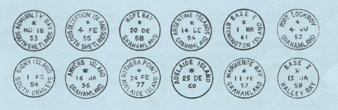
Specificando che Marguerite Bay è forse l'annullo di Horseshoe island, possiamo mostrare gli esempi degli annulli delle basi britanniche:
12 annulli usati nel tempo nelle varie basi BAT
NEWS: suggerisco di scaricare questo file PDF e di leggerlo con attenzione:
http://www.fipsg.org.uk/sitebuildercontent/sitebuilderfiles/Spink_Exhibition.pdf
Contiene moltissime informazioni sulle Falkland, le sue dipendenze e le basi in Antartide.
Ecco da pagina 31 la decodifica di tutte le basi che venivano indicate con una lettera nelle comunicazioni ufficiali:
A Port Lockroy
B Deception Island
C Cape Geddes
D Hope bay
E Stonington Island
G Admiralty Bay
H Signy Island
J Prospect Point
KG Fossile Bluff
M South Georgia
O Danco Island
T Adelaide Island
V View Point
W Detaile Island
Y Horseshoe Island
E' tutto da vedere se in tutte queste basi era usato un annullo specifico.
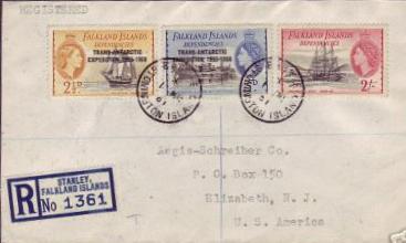
Nel 1982 tutte queste basi furono chiuse con l'eccezione delle Isole Argentine (base rinominata Faraday nel 1980), Signy, South Georgia, Adelaide (spostata e rinominata Rothera nel 1977), ed infine Halle Bay.
Nel 1962 ci fu un cambio di nome fra !Falkland Islands Dependencies Survey" a British Antarctic Survey.
Altre informazioni in inglese su queste basi sono a fondo pagina.
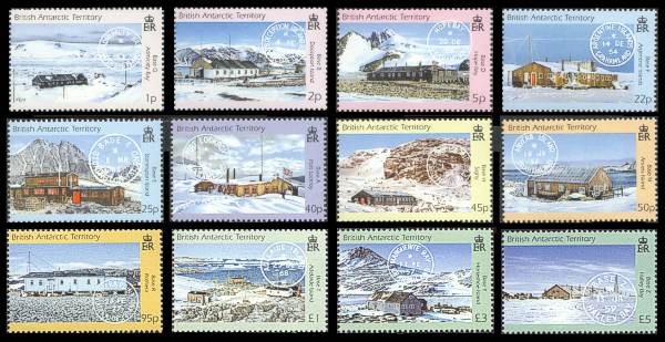
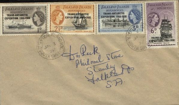
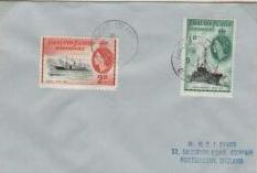
Il BAT ha emesso a fine 2003 una serie di francobolli raffiguranti le varie basi con il relativo postmark (POS che farà felice Plinio!)
una meraviglia questa carrellata delle basi britanniche in Antartide!
Vediamo ora di aggiungere qualche reperto filatelico e qualche curiosità, sotto forma di cartoline di isole della zona:
Base G Admiralty Bay South Shetland :
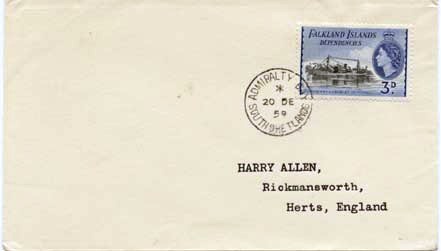
Admiralty Bay cover 1959 South Shetlands
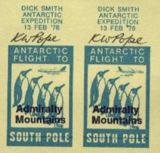
Admiralty Bay mountains: label della spedizione del 1976
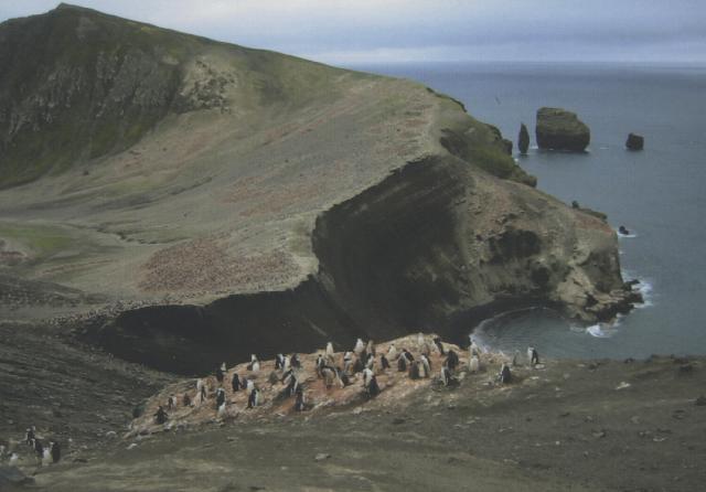
Deception island nella South Shetalnd
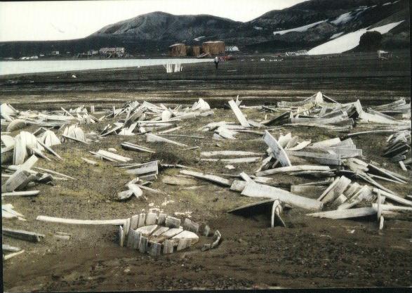
Deception island old whaling relicts South Shetland islands
Deception island South Shetland islands
Un rarissimo annullo del 1918 di Deception island - South Shetland su bolli delle Falkland:
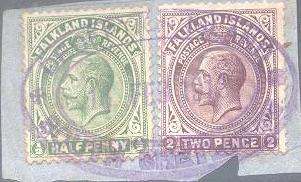
Deception island postmark 1918
Base
D Hope Bay
Hope Bay qui la base Argentina
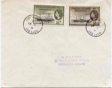
Hope Bay cover
Base
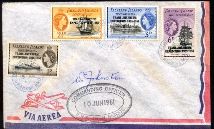
F Argentine islands
Argentine island vicino alla base F
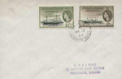
Argentine islands Grahamland postmark del 1959 su bollo delle Falkland & Dependencies
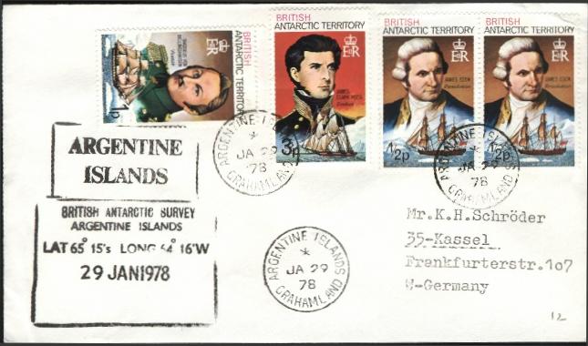
annullo del 1978 delle Argentine islands su bolli B.A.T.

etichetta del 1996 di una ipotetica posta locale di Graham land*
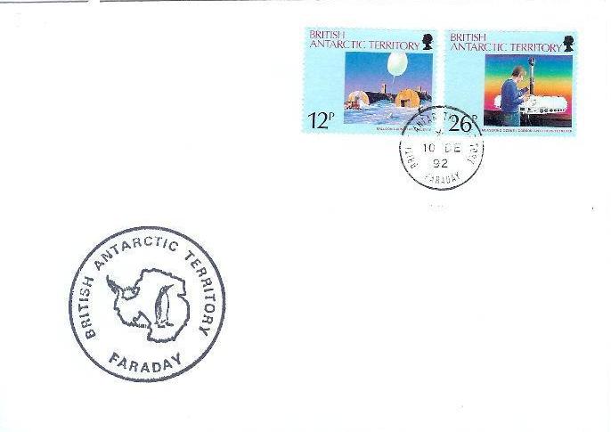
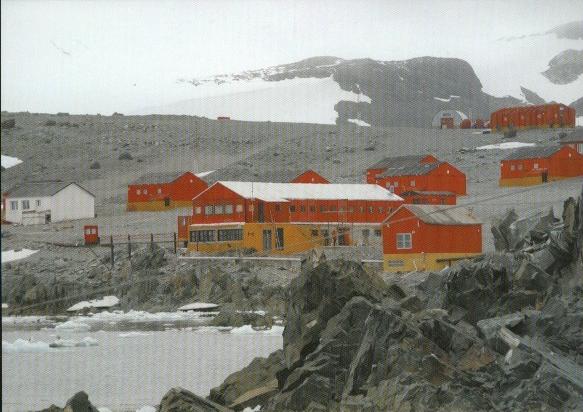
Base Faraday* cover 1992 (ex Argentine base from 1977)
Base
E Stonington Island
cover del 1962 con annullo di Stonington*

Stonington postmark Base E
.
Base
A Port Lockroy
Base Port Lockroy Wiencke island
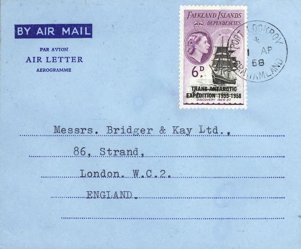
Port Lockroy Grahamland
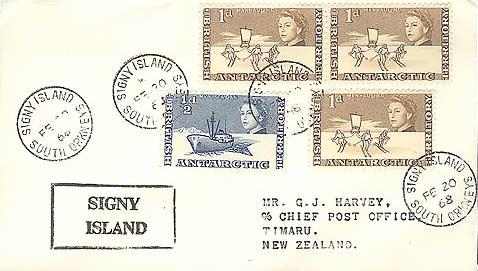
Signy island South Orkneys
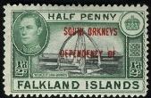
South Orkneys stamp ovpt on Falkand
South Orkneys isola di Laurie base argentina Orcadas
BASE J Graham Coast:
Base J Graham Coast
BASE N Anvers island Grahamland:

Anvers island Mt. William
Anvers island cover
Base
R Rothera
British base Rothera
Rothera base parte di cover (non filatelica)
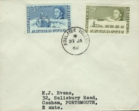
Adelaide island
Base
Y Horseshoe Island
Marguerite Bay*

Marguerite Bay* postmark on cover

1959 postmark Marguerite Bay
finalmente una mia cover con annullo di Marguerite Bay!
Halley Bay Antarctica 1995

Halley Bay cover
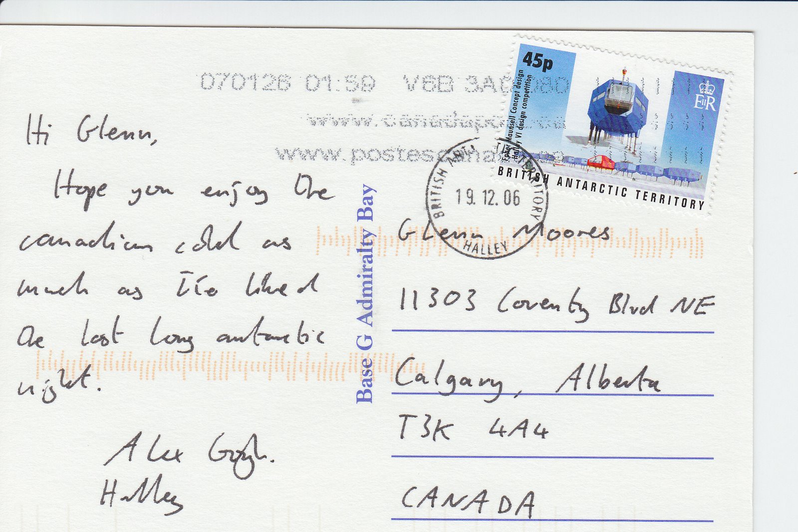
2006 Halley annullo
Base BI: Bird island station:
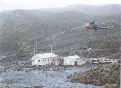
Bird island* station: rifornimenti alla base britannica
Ecco le informazioni, in inglese, sulla base Bird Island:
Freshwater Inlet, Jordan Cove, Bird Island, South Georgia
Purpose Biology (bird and seal research).
Occupied Intermittently 1957-1982. Continuously 22 Sep
1982-present.
It was used by summer parties from 1957-64 and from 1971-82. Personnel were
evacuated on 1 Apr 1982 by HMS Endurance following the Argentine invasion of
South Georgia. Reopened on 22 Sep 1982 after cessation ofhostilities.
Buildings The first permanent hut was established on 24 Nov 1958, known as Bonner's Bothy, after W N Bonner, biologist 1953-86 and Deputy Director, BAS 1986-88. In Dec 1962 the United States Antarctic Research Program (USARP) established 2 huts which were later used by BAS. One of these, used as an accommodation hut, was known as Lönnberg House after the Swedish biologist Einar Lönnberg who expressed great concern at the amount of sealing and whaling on South Georgia in 1906. A new hut was established in Oct 1981 for wintering staff, although the first wintering party was evacuated due to the Argentine invasion of South Georgia. It was named Beck House after Rolla Howard Beck, an American biologist who made extensive collections of birds around the Falkland Islands, Tierra del Fuego and the Galapagos Islands 1912-17. An extension housing the main accommodation was added in the 1996/97 season. The hut was renamed Pete Prince House in the 1998/99 season after P.A. Prince, BAS seabird biologist 1971-98 and Officer In Charge of Bird Island Station 1993-98. A further building containing laboratories, a workshop and storage areas was added in the 1995/96 season.
Field huts and hides have existed at one time or other at the following sites: Gazella Peak, Molly Hill, Wanderer Ridge, Johnson Gentoo Colony, Top Meadows, Colony B, Special Study Beach, Colony J and Fairy Point. Current Status Operational throughout the year. Governor of the Falkland Islands in 1946.
Current Status Closed. Used periodically by Argentine personnel from Orcadas Station as a bird hide and field refuge. See also Station H (Signy) and Station C (Sandefjord Bay).
Concludo aggiungendo alcune informazioni in inglese sulle basi:
British
land-based activities in British Antarctic Territory (BAT, formerly Falkland
Islands Dependancies until 1961) were undertaken at or from research bases (known
as stations after 1967) throughout the region. In 1944 the British Government
established its first stations in the Antarctic as part of the Second World War
expedition known as Operation Tabarin. Its objectives were to deter
access to anchorages by enemy ships, provide meteorological observations to help
improve weather forecasting for British shipping in the south Atlantic, and
strengthen Britain's claim to the Falkland Islands Dependencies, and also
provide the opportunity to undertake scientific work.
Operation Tabarin was a joint undertaking by the Admiralty and the
Colonial Office. In 1945 it was renamed the Falkland Islands Dependencies Survey
(FIDS), and all control passed to the Colonial Office (later absorbed nto the
Foreign and Commonwealth Office.
There were then four bases, although one was never occupied (Base C, Sandefjord
Bay, South Orkney Islands). By the time FIDS was renamed British Antarctic
Survey (BAS) in 1962 18 Antarctic stations had been established, and operated
for varying periods; another was built in 1976. Each base was designated by a
letter.
The largest number open at any one time was 13, in 1958-59, during the
International Geophysical Year, but since 1996 BAS has operated only two
overwintering stations (Rothera and Halley), and one summer-only station (Signy)
in BAT. Of these 18, all but View Point and Fossil Bluff were official post
offices. Since 1967 BAS has been a component of the Natural Environment Research
Council.
In recognition of the historical importance of early British Scientific research
in the Antarctic Peninsula region, four unoccupied British stations have been
designated Historic Sites under the Antarctic Treaty System. They are Port
Lockroy, Argentine Islands (Winter Island), Horseshoe Island and Stonington
Island.
1p Base G - Admiralty Bay, Martel Inlet, Keller Peninsula, King George
Island, South Shetland Islands (Lat. 62 05 S, Long. 58 25 W).
Admiralty Bay opened in January 1947, and another hut added in February 1948 (removed
in 1950 and re-erected at Base H). Further huts were established about 300m away
in January 1949 and in January 1956. The primary purpose of the base was geology,
meteorology and glaciology.
The station was occupied from 18 January 1947 until 23 March 1947, and from
January 1948 to 19 January 1961. It was removed by members of the Brazilian
Antarctic Expedition based at the nearby Commandante Ferraz Station in 1995/96.
From February 1946 until June 1953 the post office cancellations indicated
"Falkland Islands Dependency South Shetlands", but from November 1953
until the closure of the station in January 1961 it stated "Admiralty Bay
South Shetlands".
2p Base B - Deception Island, Whalers Bay, Deception Is;and, South
Shetland Islands (Lat. 62 59 S, Long. 60 34 W).
Deception was the first British base in the Antarctic, built during Operation
Tabarin in early February 1944. Its purpose was mainly meteorology and
geology, and later as the centre for aircraft operations in 1955-57 and from
1959-69.
Originally, buildings from the former Norwegian Aktieselskabet Haktor whaling
station were used, but the main accommodation and office building was detroyed
by fire in September 1946. Another building and the former Magistrate's Villa
were then used. A hut was erected in December 1955 for the Falkland Islands
Dependencies Aerial Survey Expedition, 1955-57, later becoming part of Base B.
An aircraft hangar was completed in March 1962.
It was occupied from Febrary 1944 until December 1967, when it was evacuated
temporarily following volcanic eruptions in the island, and from 4 December 1968
until 23 February 1969. It was evacuated again on 21 February 1969 when further
eruptions destroyed the station buildings, the remains of the former whaling
station designated as Historic Site No. 71 under the Antarctic Treaty in 1995.
The post office opened on 5 February 1944, although the postmark indicated
"Falkland Islands Dependency South Shetlands". The name Deception
Island was not used until 1953 (as "Deception Island South Shetlands").
5p Base D - Hope Bay, Hope Bay, Trinity Peninsula, northern Antarctic
Peninsula (Lat. 63 24 S, Long. 56 59 W).
This was the fourth British base built during Operation Tabarin, in
February 1945. An attempt was made to establish the station in February 1944,
but sea ice conditions prevented unloading of stores. Its main purpose was
survey, geology, geophysics, glaciology, mereorology, botany and human and dog
physiology.
The original hut was destroyed by fire in November 1948, but replaced by another
in a new position in February 1952.
It was occupied from 13 February 1945 until 4 February 1949, and from 4 February
1952 to 13 February 1964. It was transferred to Uraguay on 8 December 1997 and
renamed Teniente Ruperto Elichiribehety Uruguayan Antarctic Scientific Station.
The first mail from Hope Bay was dated 13 March 1945, the postmark indicating
"Falkland Islands Dependency Graham Land." The name changed to "Hope
Bay Grahamland" in December 1953.
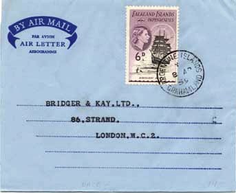
22p Base F - Argentine Islands, Marina Point, Galindez Island, Argentine
Islands, Antarctuc Peninsula (Lat. 65 15 S, Long. 64 16 W).
Base F (named Faraday station from August 1977) was opened in January 1947 and
its main purpose was geophysics, meteorology and ionospherics. It was
established on Winter Island, previously the site of the 1935/36 British Graham
Land Expedition hut. It was closed in May 1954 when the new station was built on
Galindez Island, but re-occupied in winter 1960 when personnel for Base T failed
to reach Adelaide Island.
The station was occupied continuously for 49 years and 31 days from 7 January
1947 until 6 February 1996, the longest continuous occupation of any British
station to date.
The Winter Island hut was designated Historic Site No. 62 under the Antarctic
Treaty in 1995. The Base F complex was transferred to Ukraine in February 1996
and renamed Vernadsky station.
The post office operated throughout the duration of the station. The earliest
cancellation indicated "Falkland Islands Dependency Graham land", but
from January 1954 it was "Argentine Is;ands Grahamland" and, more
recently, variants of this "Argentine Islands Graham Land", Argentine
Island British Antarctic Territory", "Argentine Islnads" and
"Argentine Is. Grahamland". From December 1980 cancellers bore "Faraday
Base British Antarctic Territory" and variants of "Faraday British
Antarctic Territory".
25p Base E - Stonington Island, Stonington Island, Marguerite Bay,
Antarctic Peninsula (Lat. 68 11 S, Long. 67 00 W).
Base E was originally intended to be sited on the east coast of Graham Land, but
this was prevented by severe sea ice conditions. Stonington Island (also known
as Marguerite Bay) was built in February 1946 for the purpose of survey, geology,
meteorology and biology. It was established near the US East Base. The station
closed in 1950 as sea ice prevented access to relieve the station in the
previous year. It reopened in 1960 as the centre for field work in the southern
Antarctic Peninsula area when Horseshoe Island (Station Y) closed. The base was
resited in March 1961, the new hut being the first two-storey building erected
by FIDS. Extensions were added in 1965 and 1972. Buildings from the US East Base
were also used.
It was occupied from 25 February 1946 until 12 February 1950, 9 March 1958 to 7
March 1959, and from 14 August 1960 to 23 February 1975. The site was cleaned up
by BAS in 1991/92 and in 2003, and designated Historic Site No. 64 under the
Antarctic Treaty in 1995.
The post office opened officially on 13 March 1946 with a canceller indicating
"Falkland Islands Dependancy Graham Land" (See also Bases A and D).
The base was closed from 1950 to 1958 when it, but not the post office were
again reopened from 1961 to 1962, when the postmark was "Base E Stonington
Island". Later mail was taken to Base T for cancelling.
40p Base A - Port Lockroy, Goudier Island, Wiencke Island, Palmer
Archipelago, Antarctic Peninsula (Lat. 64 49 S, Long. 63 30 W)
Port Lockroy was the second British base in the Antarctic, built during Operations
Tabarin in February 1944. It's purpose was initially survey, geology,
meteorology and botany. From 1950 onwards it was concerned primarily with
ionospheric research.
It was occupied from 11 February 1944 to 8 April 1947, 23 January 1948 to 14
February 1949, 24 January to 11 February 1951 and 15 December 10 16 January
1962. It reopened in January 1996 and operated during the summers since then.
The ionospheric work was transferred to Base F when Base A closed in 1962. In
1995 it was designated Antarctic Historic Site No. 61 under the Antarctic Treaty.
The buildings were restored, and the site tidied, by BAS in 1996 and, since
November 1996, the station has been maintained by the UK Antarctic Heritage
trust for the benefit of tourists and visitors during summer. In 2003, it
recieved visits from at least 86 cruise ships and 37 yachts, with approximately
8500 tourists coming ashore.
The first cancelled mail from this post office was dated 12 Fabruary 1944,
although the postmark indicated "Falkland Islands Dependancy Graham
Land". The name Port Lockroy was not included in the postmark until 1953 (as
Port Lockroy Grahamland"). Port Lockroy probably ranks as the smallest post
office in the world in terms of resident population (2, occasionally 3).
45p Base H - Signy, Factory Cove, Borge Bay, Signy Island, South Orkney
Islands (Lat. 60 43 S, Long. 45 36 W).
Signy (known as Signy Island until August 1977) wsa BAS' primary biological
research station until 1996, when much of the science was transferred to Rothera
station. The original building was erected in March 1947. A laboratory was added
in February 1948 and a hut transferred from Base G in February 1950. These
buildings were resited close to the shore in Factory Cove in February 1955 on
the site of the small 1029s Tønsbergs Hvalfangeri whaling station. A
two-storey hut with living accommodation and laboratories was built in 1963/64.
Another building was erected December 1980, demolished in March 1995 and
replaced with a small accommodation and laboratory complex for eight persons in
1995/96. BAS undertook a major cleanup of the site in 2002/03, removing several
buildings and a large steel fuel tank.
The station was occupied continuously from 18 March 1947 until 13 April 1996 (49
years 27 days), then for summers only from 1996/97 to present making it Britain's
oldest operational station.
Signy post office opened in March 1947, using the same canceller that had been
used during the previous year at the second station , Cape Geddes, on Laurie
Island. The wording was "Falkland Islands Dependency South Orkneys".
In July 1953 a new canceller indicated "Signy Island South Orkneys".
There were several subsequent versions, including one in 1973-74 with "Signy
Is;ands South Orkneys". From December 1981 the canceller has indicated
"British Antarctic Territory Signy".
50p Base N - Anvers Island, Arthur ISland, southern Anvers Island, Palmer
Archipelago, Antarctic Peninsula (Lat 64 46 S, Long. 64 05 W).
Anvers was built in February 1955 for the purpose of survey and geology. After
it's closure, the hut was loaned to the US government in 1963 who converted it
into a biological laboratory in 1965 prior to the completion of nearby Palmer
Station. The building was destroyed by fire during renovation in December 1971.
Debris was removed by the US Antarctic Program in 1990/91.
The base was occupied from 27 February 1955 until 10 January 1958, when local
work was completed. It reopened in support of air operations from 1969 to 1971.
The skiway near the station was in use from 1969 until 1973 and intermittently
until December 1999. Air operations were rtansferred to Adelaide (Base T) in
1973 when the skiway deteriorated.
Postal services operated from January 1956 until January 1958, the canceller
indicatin "Anvers Island Grahamland".
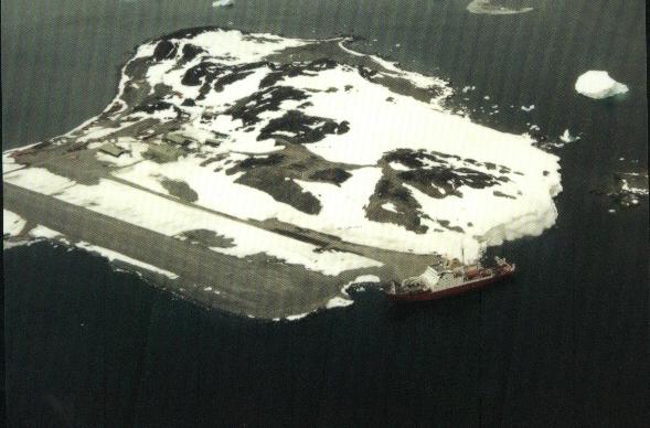
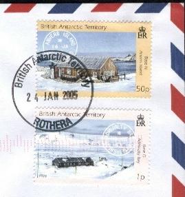
95p Base R - Rothera, Rothera Point, south-east Adelaide Island, southern
Antarctic Peninsula (Lat. 67 34 S, Long. 68 08 W).
Rothera (known as Rothera Point until 15 August 1977) is the largest of the BAS
research stations, accommodating up to 128 (in 2003) persons during summer.
Research programmes incluse survey, glaciology, geology, geophysics, biology and
meteorology. It is the main air facility with currently four Twin Otter and one
Dash-7 aircrafy serving scientific investigations in remote regions. The station
was established as a replacement for Base T where the skiway had deteriorated.
Rothera Point has access to a skiway and a good harbour. The station has been
occupied from 25 Octover 1975 to present.
The first building was erected in February 1976, and others followed in 1976/77
(including one transferred from Base T), 1978/79, 1985/87, 1996/97 (including a
large biological laboratory, destroyed by fire in 2000 and rebuilt in 2002/03),
and 1999/2001 (large accommodation building). A wharf, gravel runway, fuel tanks
and hangar, became operational in 1991/92.
Initiallt, mail was taken by ship to Base T, prior to its closure, for posting.
Rothera post office officiallt opened in February 1977, the canceller bearing
the name "Rothera Point Adelaide IslAnd" and, from March 1982 "British
Antarctic Territory Rothers" in various forms.
£1 Base T - Adelaide, south-west Adelaide Island, southern Antarctic
Peninsula (Lat. 67 46 S, Long. 68 55 W).
Prior to Base R, Adelaide (known as Adelaide Island until January 1962) was BAS'
main air facility and centre for airborne survey, glaciology and geology
programmes, and also undertook meteorological research. It was established in
February 1961, and another hut was erected in March 1962. A seperate
accommodation hut, transferred from Fossil Bluff (Base KG) on eastern Alexander
Island, was erected in January 1963. A new accommodation building was
established in March 1967. It closed when the Skiway deteriorated and operations
were transferred to Rothera.
It was occupied from 3 February 1961 until March 1977. The station was
transferred to Chile on 14 August 1984 and renamed Teniente Luis Carvajal
Villaroel Antarctic Base (Teniente Carvajal).
The Adelaide post office opened in late January 1963, before which mail had been
taken to Stonington (Base E) for cancelling. The canceller indicated
"Adelaide Island" in two versions.
£3 Base Y - Horseshoe Island, Bourbeois Fjord, Marguerite Bay, southern
Antarctic Peninsula (Lat. 67 49 S, Long. 67 18 W).
Horseshoe Island base was built in March 1955 for the purpose of survey, geology
and meteorology. It closed in 1960 but reopened briefly in 1969, and has been
used intermittently by personnel from Rothera station. The site was cleaned up
by BAS in 1995, and designated Historic Site No. 63 under the Antarctic Treaty
in 1995. Building conservation work was undertaken in 1997. It was occupied from
11 March 1955 until 21 August 1960 and 7 March 1969 to 11 July 1969.
Like several of the small bases operating in the 1950s, the Horseshoe Island
post office was short-lived, opening in January 1956 and closing in March 1960.
The canceller indicated "Marguerite Bat Grahamland".
£5 Base Z - Halley, Brunt Ice Shelf, Caird Coast (currently Lat 75 35 S,
Long. 26 34 W).
There have been five Halley stations (known as Halley Bay until August 1977).
Approximately 1.2m of snow accumulates each year and buildings on the surface
become bruised and eventually crushed by ice, neccessitating periodic rebuilding
of the station. The ice shelf here is moving westward by about 7800m per year
(in 2001), periodically fracturing and detaching from the continental mainland,
and drifting into the Weddell Sea. The station was build primarily for upper
atmosphere research, but also survey, geology, glaciology and meteorology. It
has been occupied continuously since 6 January 1956.
Halley I was established by the Royal Society of London in January 1956 for the
International Geophysical Year 1957/58. FIDS took over the operation of the
station in January 1959, with further buildings added in February 1961. It
closed in 1968 and was replaced bu Halley II (1967-1973), Halley 3 (1973-1984;
the site was cleaned up in 1991), and Halley IV (1983-1992; the site was cleaned
up in 1992/93). Halley V was built in 1989/92 on platforms which are raised each
year so that the buildings remain obove the ice surface.
The Halley post office first operated (as the Royal Sicuety's base) from
February 1956 to January 1959, the canceller indicating only "International
Geophysical Year Expedition". From January 1959 the canceller bore
"Base Z Halley Bay", with later versions stating "Halley
Bay" in various forms, "British Antarctic Territory Halley" and
British Antarctic Surveys Halley" (1983 only).
---------- °°°° -------------
Aggiungerò le cover mancanti appena disponibili.
Per argomenti correlati cerca le pagine con le parole chiave: Polare, Antarctic, isole estreme, EXTREME, external territories e visitate i link elencati ad inizio pagina.
------------------- °°°°°°°°°°°°°° --------------------
Mi
scuso per eventuali imprecisioni, infatti, per risparmiare tempo,
mi sono affidato solo alla mia memoria. Per certo posso fornire le fonti -
sicuramente più attendibili di me - da cui ho tratto le varie informazioni.
Se volete approfondire i vari argomenti, contattatemi. P.S.
Su questo sito potete vedere immagini, articoli e approfondimenti
ai temi discussi nei miei messaggi per il forum Filatelia e Francobolli.
Chi
fosse interessato ai bolli della seconda guerra mondiale, a quelli dei
prigionieri di guerra o di propaganda psicologica, alla resistenza, nonché
alla storia contemporanea, incluse le missioni di pace italiane nel mondo e
quelle scientifiche al polo sud, può visitare le oltre 500 pagine, in italiano
ed in inglese, del sito, cliccando semplicemente sul tasto
"Iniziale" qui sotto. Gli
altri tasti aiutano la navigazione all'interno di questa sezione "le
storie dietro i francobolli" e "Curiosità filateliche". Precisamente:
il sommario riporta gli argomenti trattati in ogni pagina; i tasti dall' 1 al 96
aiutano ad accedere direttamente alle prime xx pagine (12 per volta) ed infine c'è il link
alla corrispondente pagina/pagine del Forum di F&F in cui lo stesso "topic"
è stato discusso. ![]() NOVITA': Se cercate uno specifico argomento ed il Sommario
non è esauriente, potete provare con il nostro motore di ricerca. Esso funziona
all'interno del sito, e può essere utilissimo. Basta scrivere la
parola che si cerca, nel rettangolo qui sotto e cliccare a destra su "find".
La ricerca può essere
fatta con una singola parola, con più parole ed anche con un * alla fine di una
parola se si vuole interrogare sia il singolare che il plurale di una parola.
Per esempio facendo la ricerca con la parola mission*
si cercano tutte le pagine del sito, che contengono le seguenti parole:
missione, missioni ed anche mission, e missions, etc. NOVITA'
NOVITA': Se cercate uno specifico argomento ed il Sommario
non è esauriente, potete provare con il nostro motore di ricerca. Esso funziona
all'interno del sito, e può essere utilissimo. Basta scrivere la
parola che si cerca, nel rettangolo qui sotto e cliccare a destra su "find".
La ricerca può essere
fatta con una singola parola, con più parole ed anche con un * alla fine di una
parola se si vuole interrogare sia il singolare che il plurale di una parola.
Per esempio facendo la ricerca con la parola mission*
si cercano tutte le pagine del sito, che contengono le seguenti parole:
missione, missioni ed anche mission, e missions, etc. NOVITA'
![]() QUI LA SEARCH ENGINE per ricerche all'interno di tutto il sito:
QUI LA SEARCH ENGINE per ricerche all'interno di tutto il sito:
N.B. Le schermate sono state ottimizzate per video a 17 pollici e collegamento ADSL, per cui molte righe ed immagini potrebbero risultare distorte, spostate o lente a scaricarsi, su altri schermi o computer con vecchi modem. Nel caso scrivetemi che provvederò a fare migliorie specifiche.
 |
 |
|
 |
 |
